Try mapping a 500-hectare mine site using a quadcopter! The amount of time you’ll be replacing batteries versus acquiring data will have you going crazy. For operators in Canada working from the Rockies to the Maritimes, the limiting factor is not the resolution of their sensors but how long they can remain airborne without a runway team.
This is the reason that teams are adopting a fixed-wing VTOL for corridor surveys and pairing it with a waterproof mapping drone for surveys where lakes, coastline, or snow is part of the flight plan. This article is about why that pairing will be the winner in 2026, what to look for, and how it alters your mission economics.
Why Large-Area Data Collection Demands A Different Platform
Traditional multirotors are fantastic for inspection tasks, but hover efficiency restricts flight time to 25-35 minutes. Light aircraft can cover great distances but require an airport, a pilot, and a cost of $3000 per day. The middle ground has evolved quite rapidly.
According to market data, fixed-wing VTOL drones make up 41.2% of the agriculture mapping market share by 2025 because they can fly for 55-90 minutes, covering between 500 and 1,200 hectares in a single flight mission. By integrating the ability to take off vertically and fly wing-borne, the runway is eliminated, but the speed is still there for the required photogrammetry overlap.
The implication for BVLOS work is significant: enabling the legally mandated range without requiring visual observers at each kilometer interval.
How Fixed-Wing VTOL Bridges The Gap Between Endurance And Access
The fixed-wing VTOL can vertically take off as a heli, switch to economical forward flight, and land vertically or in a slight belly slide. No catapult, no net.
Runway-Free Operations In Remote Canadian Terrain
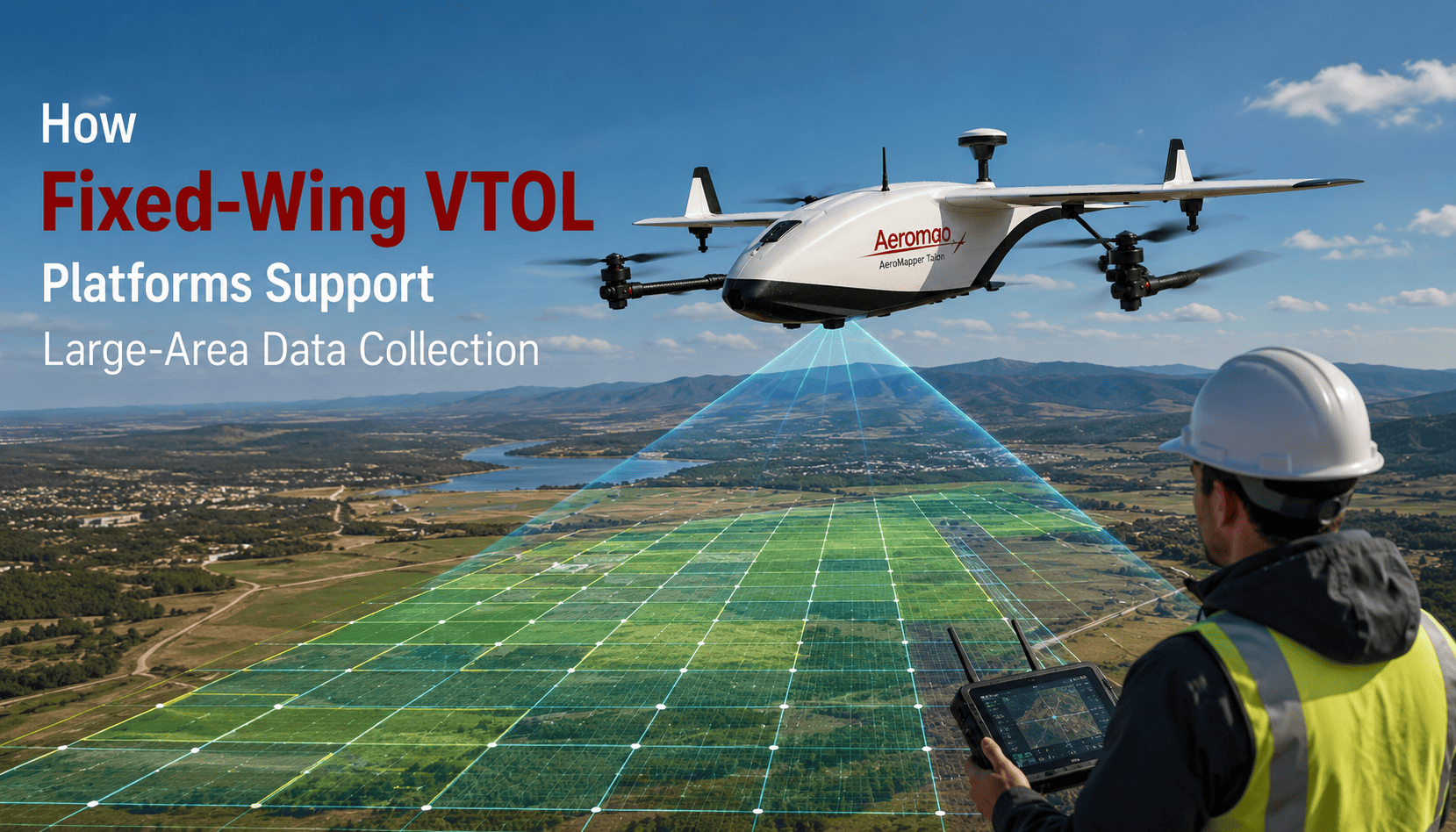
The Canadian-built Aeromao VT-Naut illustrates the equation: 3.7 kg all-up weight, 1.96 m span, 90-minute flight time, and 30 km datalink supporting 70 km linear missions. 540 ha (1,330 acres) can be mapped with a single flight at 120 m altitude at 3 cm/px. That is roughly on par with the XAG M2000, which is claimed, based on an industry source, to map 533 ha/hr during 90 min flights. For northern BC mining crews or Quebec forestry teams, this is one operator, one pickup truck, and one remote field—no runway.
Efficiency Metrics That Matter
- Launch to mapping in 2 minutes: VT-Naut setup is less than 120 seconds.
- Wind tolerance up to 35 km/h: crucial for gusts in prairies or on coasts.
- PPK accuracy: integrated dual-band GNSS reduces the need for ground control points, while Reach M2 kits support baselines up to 100 km.
Five-motor tilt-rotors will still carry dead weight in cruise, but a tail-sitter keeps aerodynamics clear. Thus, Aeromao suggests that the optimum is simplicity and, therefore, reliability for long missions.
Weather And Water Are No Longer Showstoppers
Canadians fly their craft through -20°C through +40°C, light snow and coastal spray; their standard foam airframe does not cope well for long.
Why A Waterproof Mapping Drone Changes Mission Planning
A waterproof, water-landing fixed-wing with amphibious capabilities allows a pilot to take off from a gravel pad and land on any body of water (lake, river, or ocean). The Aeromao VT-Naut is being promoted as the world’s first vertical takeoff, water-landing, fixed-wing UAV for mapping, a sister to its Talon Amphibious, which is already in use with the UN FAO Philippines.
The Talon Amphibious is used for maritime reserves and has been used with up to 2 hours of flight time and 30 km of link range to satisfy Transport Canada regulations. This platform was also flown offshore at the Turneffe Atoll in Belize for BVLOS mapping and surveillance of illicit fishing.
The Talon Amphibious could be used over hydropower reservoirs, for Arctic coastline monitoring, or for flood survey work in the Fraser Valley, and the water landing eliminates hand-catching on a boat’s deck.
Choosing the Right Platform
If you have hundreds of hectares, remote launch sites, or volatile weather, the mathematics becomes basic. The answer to a plane with the flight endurance of an airplane but with drone-type logistics is, in both cases, a fixed-wing VTOL, and a waterproofing drone will not make your flight a failure by forcing a landing at sea when it’s the only secure place left.
Aeromao, a Canadian designer and manufacturer of fixed-wing UAVs and GNSS systems designed for mapping and remote sensing, produces precisely the type of equipment: the long-endurance Talon and the VTOSL VT-Naut, which takes off and recovers amphibiously.
FAQs
1. Is a fixed-wing VTOL better than a quadcopter for mapping?
Yes for large areas >100 hectares. A fixed-wing VTOL has 3-4x the flight time since its wings generate lift during cruising, whereas a multi-rotor is inherently poor at hover efficiency.
2. How much area can one flight cover?
According to VT-Naut and M2000 specs, you may expect 500-540 ha per 90-minute flight at 120 m altitude with a 24-61 MP payload.
3. Do I need a runway?
No, VTOL vehicles are vertically landing and taking off crafts, so they do not need runways and can land on water or a belly skid. This would be a perfect choice for isolated sites across Canada.
4. Can these drones fly in winter or rain?
That’s right. Canadian design platforms can function in -20°C to +40°C and in light rain or snow; amphibious types are fully waterproof for water landings.
5. What makes them BVLOS-ready?
Long-range 30-km links, ADS-B traffic awareness, PPK GNSS, and TC design requirements can aid BVLOS applications for wide areas.